The Government says it wants to align the boundaries of England’s public institutions with new strategic authorities. Yet recent reforms in areas like health and policing reveal competing pressures, as long-standing beliefs about the “right” scale for delivering services continue to shape the map of the local state, writes Mark Sandford, Senior Research Analyst at the House of Commons Library.
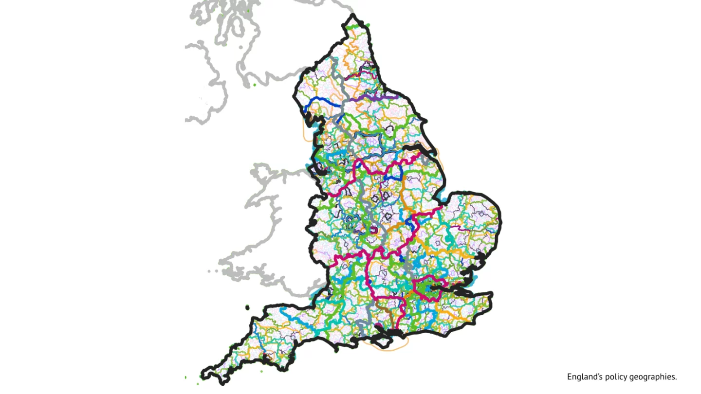
To misquote Disraeli, England does not love boundaries. The UK has always been governed on a functional, not a territorial, basis. Health services, policing, fire authorities, environmental bodies, and cultural organisations all operate across different sets of boundaries, each shaped by government departments’ views about their operational needs. ‘Coterminosity’ – alignment of boundaries – has been conspicuous by its absence.
Departments have often created regional structures based on assumptions about the scale required to deliver particular services; at other times, historical boundaries have been used as building blocks. Those same assumptions have contributed to reforms that have reduced the number of local authorities in England while increasing their population size
Intuitively, differences in boundaries and geographies make it more complex for these different bodies to work together, or to work alongside local authorities. In this environment, the government’s commitment in the English Devolution White Paper, to “seek to promote alignment between devolution boundaries and other public sector boundaries” is a break with recent practice. This is the type of bureaucratic change that does not generate easily visible results but can easily become a sinkhole for political capital. Local government reorganisation and mayoral authorities are absorbing much bandwidth for the Government, so it would not be surprising if this aim got forgotten.
This blog argues that there are indications that the Government is still committed to harmonising boundaries. However, counter-developments have also been under way, driven by often tacit beliefs about the appropriate scale for effective service provision or administrative efficiency (two amongst many dimensions of scalecraft).
Why align boundaries?
It seems intuitive that local public sector bodies should align their geographies. Governing the same area means that they can develop joint strategic plans, pool budgets, and share economic and demographic data. The Government’s Written Statement of 9 Sep 2025 said that “aligning public service boundaries facilitates service integration, harnesses the opportunities of strategic planning between the NHS and strategic authorities, and supports delivery of a ‘health in all policies’ approach”.
The Future Governance Forum’s concept of mayors as ‘stewards of the regional system’ cites similar roles made easier by aligned boundaries.
These types of outcome are particularly important to strategic authority mayors. The Government expects them to convene local partners, collaborate with other public sector bodies on policy, and develop strategic plans in partnership with central government. The White Paper contains some two dozen commitments from the UK government to enhancing joint working with mayors.
‘Completing the map’ and spatial planning
The White Paper also included a commitment to ‘complete the map’ – to establish mayoral or non-mayoral strategic authorities throughout England. At the time of writing there are 22 existing or planned mayoral authorities. On 12 February 2026, the Government invited submissions from local areas for new ‘foundation strategic authorities’, in all areas of England that do not have existing mayoralties or strategic authorities.
On the same day the Government released a list of areas for producing spatial development strategies (SDSs). The Government’s maps show eight further areas which have submitted devolution proposals in the past but which the Government has not yet taken forward. The maps also include some residual ‘grey areas’, and the Government invites proposals for SDS boundaries in these areas. In that request they reference “the prospective alignment of public service delivery boundaries, for example, for Integrated Care Boards, Police and Crime Commissioners and Fire & Rescue Authorities.” The Government has also said that strategic authority and SDS geographies are explicitly expected to align.
But alongside the framework of devolution in England, public sector reform in the NHS and in policing has also begun to explore changing boundaries. In both cases, publications outlining change acknowledge the desirability of boundaries aligning with strategic authorities: but they also highlight ideas of the ‘requirements’ of service delivery.
NHS reform
The NHS’s main service delivery arm consisted, until 2026, of 42 Integrated Care Boards (ICBs). Many of these boards shared geographies with local authorities. In 2026 and 2027, they are to be reorganised and allocated to larger geographical ‘clusters’. Some new ICB boundaries will take effect in April 2026 and some in April 2027.
The NHS Confederation has published a series of maps of the new geography. The struggle between the push to align with other public sector boundaries, and the demands of efficiency, is inscribed on the new maps. On the one hand, in mid-2025 the Government’s 10 Year Health Plan said “Our aim is that ICBs should be coterminous with strategic authorities wherever feasibly possible”.
This has been acknowledged in the changes in April 2026. For instance, the proposed new ICBs align with strategic authority boundaries in Norfolk and Suffolk, Essex, the West Midlands, and Hampshire and the Solent. When announcing the 2026 changes, the Government said that “In the case of Thames Valley ICB and Central East ICB, we are progressing with these new ICB footprints on the understanding that these may be reviewed in future to allow for alignment with any future strategic authorities.”
But elsewhere – and for no evident reason – boundaries are misaligned. One proposed new ICB covers the East Midlands and part of the Greater Lincolnshire strategic authorities. Another covers the area of ‘Wessex’ (Somerset, Dorset and Wiltshire); but it also covers Swindon and Bath, neither of which are in ‘Wessex’ in the spatial development consultation.
Reviewing policing boundaries
Similar tensions are visible in the January 2026 police white paper. This promotes ‘reintegrating’ police forces with local government. It launched a review of police area boundaries, and explicitly mentions alignment with other public sector bodies. But it also says that the review will “significantly reduce” the number of police forces, from the current 43 in England and Wales. Although it says that “where a force area is wholly within the area of a Strategic Authority Mayor, that Mayor should become responsible for its governance”, it also includes the option of boards comprising mayors and other local leaders. That leaves open the prospect of police forces that are significantly larger than strategic authorities – an option critiqued as unproven by the Institute for Government.
Will aligning boundaries make things better?
English local government has become increasingly fragmented over the last 50 years. It has borne the brunt of successive reforms to individual organisations that have ignored any wider context. Aligning public sector boundaries is one of a number of small steps toward de-fragmenting the local state. Another step is the powers of mayors to develop statutory plans and strategies to which other public sector actors must ‘have regard’, such as the Local Growth Plan.
For now, the existing mayoral authorities, and those on the Devolution Priority Programme, have locked in their existing geographies. But these can themselves be contentious: they are not ‘real’ geographies that can command immediate assent across government. Commentators such as Philip McCann and the Institute for Government have suggested that many mayoral geographies are too small. They often reflect a compromise between functional economies, established service delivery units, and local political relationships. Similarly, many parts of England do not fall into a ‘natural’ regional geography that garners instinctive assent from stakeholders or the public.
Aligning boundaries and designing geographies for local leadership and service delivery is therefore a very movable feast. Much of the decision-making demands judgements, or leaps of faith. Although boundary alignment is intuitive, it is hard to prove that aligned boundaries consistently lead to better decision-making or value for money – or to prove that they do not. How successful the Government’s push towards alignment turns out to be will depend on broader political trends in the remainder of the Government’s term of office.
Animated maps: England’s policy geographies. By Dr Jack Newman.
The views and opinions expressed in this post are those of the author(s) and not necessarily those of the Bennett School of Public Policy.